Context: The doubling of Foreign Direct Investment (FDI) inflows into Information Technology (IT) sector in the first half of FY26 (H1FY26) helped the southern States of Karnataka and Tamil Nadu raise their share in total FDI even as Maharashtra and Gujarat saw their shares shrink.
FDI into India stood at $35.2 billion in H1FY26 (April-September 2025), up 18% from $29.8 billion in the same period last fiscal, official data show.
The FDI growth was driven by a two fold jump in inflow into the IT sector (categorised as ‘Computer Software & Hardware’) to $9 billion in H1FY26. With this, the sector’s share rose up to 25% of the total FDI flow compared with 14% in the prior period.
Still in pole position
Maharashtra, still at the top position, saw a reduction in share of total FDI in H1FY26 to 30% vs. 45% ($10.6 billion). Gujarat’s share halved to 6.4% while Karnataka with $9.4 billion and Tamil Nadu with $3.6 billion were at second and third spot in overall tally.
FDI into e-commerce majors Meesho and Flipkart, from foreign promoter entities and investors, dominated the top deals. Large PE investments in Access Healthcare Services and Haldiram Snacks and investments by Ardour Investment Holdings in Adani Green Energy were also among the top deals. A $0.8 billion FDI into Raiden Infotech, a subsidiary of Google, for data centre business was another key FDI during this period.
Madhavi Arora, chief economist, Emkay Global; the change in FDI shares of States was a function of India receiving more services FDI compared with manufacturing. GCCs and new-age technology firms were concentrated in the Southern states, especially Karnataka.
Sectorally, the “Services” sector (which is said to include other services besides technology) and ‘non-conventional’ energy saw a decline in the FDI inflows in this half year.
In terms of origin, Singaporeled the way with a significant $12 billion invested accounting for 34% of the total FDI.
The U.S. and Mauritius followed with $6.6 and $3.5 billion respectively.
Context: Samudra Pratap, built with over 60% indigenous content, will substantially enhance the Coast Guard’s capability in fire-fighting, maritime safety, environmental protection, and surveillance.
Defence Minister Rajnath Singh commissioned the Indian Coast Guard Ship ICGS Samudra Pratap, the first of two indigenously designed pollution control vessels (PCVs) for the Indian Coast Guard (ICG), in Goa.
The Minister described the ship, built with over 60% indigenous content, as a symbol of India’s maturing defence industrial ecosystem.
The vessel was built by Goa Shipyard Limited (GSL).
The Defence Ministry: Samudra Pratap is India’s first homegrown pollution control vessel and the largest ship in the Coast Guard’s fleet so far. Its induction substantially enhances the ICG’s capability in pollution response, fire-fighting, maritime safety, environmental protection, and extended surveillance across the country’s vast maritime zones.
Commissioning the ship, Mr. Singh reiterated the government’s goal to increase indigenous content in warships to 90%. He said the vessel integrated multiple roles on a single platform, making it effective not only for pollution control but also for coastal patrol and maritime security in today’s complex maritime environment.
The ship is equipped with advanced pollution detection systems, specialised pollution response boats, modern firefighting equipment, and aviation facilities including a helicopter hangar, enabling greater operational reach even in rough sea conditions.
Protecting marine life
Mr. Singh noted that these capabilities would ensure rapid detection and containment of pollution incidents, helping protect coral reefs, mangroves, fisheries, and marine biodiversity, directly supporting coastal communities and the blue economy.
Emphasising that marine environmental protection is both a strategic necessity and a moral responsibility, the Defence Minister praised the ICG’s role in oil spill response, maritime law enforcement, and coastal cleanliness.
Women officers
In a notable first, Samudra Pratap will have two women officers aboard. Mr. Singh hailed it as a proud step towards a more inclusive and gender-neutral Coast Guard, highlighting the growing role of women in frontline maritime operations.
Reaffirming the government’s commitment to modernising the ICG, he stressed the need for an intelligence-driven and integration-centric force to address emerging technology-led threats. He expressed confidence that Samudra Pratap will significantly strengthen India’s maritime governance.
India has introduced an e-Production Investment Business Visa called e-B-4 Visa that Chinese businessmen can apply for to travel to India for specific business activities, including installation and commissioning of equipment. A latest advisory on the Indian Embassy website here said the e-B-4 Visa, which was introduced on January 1, can be applied for online without visiting the embassy or agents. The new visa is introduced in view of the growing demand for business visas to travel to India. It will be issued in about 45 to 50 days, with permission to stay in India for up to six months.
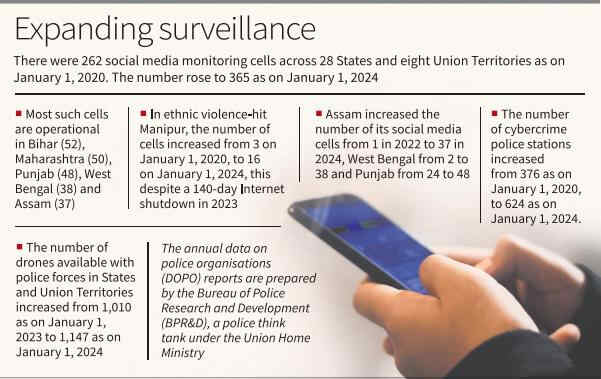
Context: Dedicated cells rise from 262 in 2020 to 365 in 2024; numbers high in Bihar (52), Maharashtra (50), Punjab (48), West Bengal (38) and Assam (37); officials cite evolving crime trends for rise in cells.
Over the past five years, police forces across States have dedicated significant resources to monitoring social media platforms, an analysis of police infrastructure data shows. The number of dedicated social media monitoring cells rose from 262 across 28 States and eight Union Territories as of January 1, 2020, to 365 as of January 1, 2024.
Most of such cells are operational in Bihar (52), Maharashtra (50), Punjab (48), West Bengal (38) and Assam (37).
In Manipur, where ethnic violence erupted on May 3, 2023, the number of police social media monitoring cells rose from three on January 1, 2020, to 16 on January 1, 2024. The expansion occurred despite the Internet being suspended in the State for about 140 days in 2023.
Assam increased the number of social media monitoring cells from one in 2022 to 37 in 2024. West Bengal expanded its network from two to 38 cells, while Punjab doubled its capacity, increasing the number from 24 to 48 between 2022 and 2024.
Earlier, social media monitoring cells were not counted separately or were part of the cybercrime police stations. They began to function as distinct units from 2021, according to Data on Police Organisations (DoPO) reports for the years 2020, 2021, 2022, 2023 and 2024.
The annual DoPO reports are prepared by the Bureau of Police Research and Development (BPR&D), a police think tank under the Union Home Ministry.
The cells started featuring in the reports since 2021, which includes data for the 2020.
Meanwhile, the number of cybercrime police stations increased from 376 as of January 1, 2020, to 624 as of January 1, 2024.
‘Evolving crime trends’
Police officials attribute the need for dedicated cells to track and pre-empt the evolving crime trends on social media platforms such as Facebook, X, Snapchat, WhatsApp and Instagram.
The 2024 DoPO report said that the number of drones available with police forces in States and Union Territories stood at 1,147, up from 1,010 as of January 1, 2023.
The report also noted that 5,92,839 police posts were vacant across the country, against the total sanctioned strength of 27,55,274.
Of the total sanctioned strength of 27.55 lakh, the actual strength comprised 3,30,621 personnel belonging to Scheduled Castes, 2,31,928 to Scheduled Tribes and 6,37,774 to Other Backward Classes.
Context: Minister for Revenue Krishna Byre Gowda launched the Bhu Suraksha Project to expand the digitisation of land records to the offices of Assistant Commissioners (ACs) and Deputy Commissioners (DCs).
‘To curb malpractice’
Karnataka’s land records were being fully digitised to curb malpractice and improve transparency.
The original land records in all taluk offices had been scanned and digitised. Digitisation plays crucial measure to prevent fake entries and the creation of forged documents in land records.
Work under the Bhu Suraksha project to digitise records in AC and DC offices had begun last month.
Suspicious cases
Of the forged land documents, treated with seriousness.
“Each suspicious case will be examined thoroughly. Wherever required, documents will be sent to forensic laboratories to verify their authenticity, and appropriate action will follow,”.
📌 Key Highlights of the Bhu Suraksha Project Launch Date: January 5, 2026, in Bengaluru.
Launched By: Revenue Minister Krishna Byre Gowda.
Objective: To digitise Karnataka’s vast land records and make them easily accessible online.
Scale: Karnataka has an estimated 100 crore pages of land records, of which 62 crore pages have already been scanned.
Coverage Expansion: Digitisation will now extend to the offices of Assistant Commissioners (ACs) and Deputy Commissioners (DCs).
Technology Use: Advanced scanning and digital archiving to ensure secure, tamper-proof records.
🏛️ Why It Matters Transparency: Eliminates scope for manipulation of land records.
Accessibility: Citizens can access verified land documents online without middlemen.
Legal Security: Prevents fake entries and forged documents, reducing land disputes.
Efficiency: Streamlines land administration and reduces delays in property transactions.
⚠️ Challenges & Risks Completion Timeline: Scanning of all records is targeted by March 2026, requiring massive coordination.
Data Security: Ensuring protection against cyber threats is critical.
Training Needs: Revenue staff must adapt to digital workflows.
Citizen Awareness: Rural populations need guidance on accessing digital records.
✨ Significance The Bhu Suraksha Project is a landmark initiative in Karnataka’s governance, aligning with Digital India goals. By digitising land records, the state aims to provide secure land ownership, reduce disputes, and empower citizens with transparent access to property information.
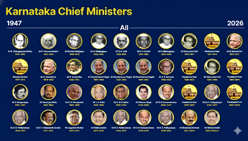
Chief Minister Siddaramaiah equals the record of D. Devaraj Urs as Chief Minister with the longest tenure in Karnataka. Both hailed from Mysuru.
Karnataka’s Longest-Serving Chief Ministers While Karnataka is known for its competitive and often volatile political landscape, a few leaders have managed to maintain extended leadership across multiple terms.
Chief Minister
Party
Total Tenure
Key Contributions
Siddaramaiah
Congress
7 years, 240+ days
AHINDA leadership, “Guarantee” welfare schemes.
D. Devaraj Urs
Congress
7 years, 239 days
Landmark land reforms and social justice policies.
S. Nijalingappa
Congress
7 years, 175 days
Architect of modern unified Karnataka.
Ramakrishna Hegde
Janata
~5 years, 214 days
Decentralization and Panchayat Raj reforms.
B.S. Yediyurappa
BJP
~5 years (total)
Focus on agriculture and infrastructure.
List of Chief Ministers of Karnataka (1947–2026)
No.
Chief Minister
Tenure
Party
1
K. C. Reddy
1947–1952
Congress
2
Kengal Hanumanthaiah
1952–1956
Congress
3
Kadidal Manjappa
1956 (Aug–Oct)
Congress
4
S. Nijalingappa
1956–1958
Congress
5
B. D. Jatti
1958–1962
Congress
6
S. R. Kanthi
1962 (Mar–Jun)
Congress
7
S. Nijalingappa
1962–1968
Congress
8
Veerendra Patil
1968–1971
Congress
9
D. Devaraj Urs
1972–1977
Congress
10
D. Devaraj Urs
1978–1980
Congress
11
R. Gundu Rao
1980–1983
Congress
12
Ramakrishna Hegde
1983–1988
Janata Party
13
S. R. Bommai
1988–1989
Janata Dal
14
Veerendra Patil
1989–1990
Congress
15
S. Bangarappa
1990–1992
Congress
16
M. Veerappa Moily
1992–1994
Congress
17
H. D. Deve Gowda
1994–1996
Janata Dal
18
J. H. Patel
1996–1999
Janata Dal
19
S. M. Krishna
1999–2004
Congress
20
N. Dharam Singh
2004–2006
Congress
21
H. D. Kumaraswamy
2006–2007
JD(S)
22
B. S. Yediyurappa
2007 (Nov)
BJP
23
B. S. Yediyurappa
2008–2011
BJP
24
D. V. Sadananda Gowda
2011–2012
BJP
25
Jagadish Shettar
2012–2013
BJP
26
Siddaramaiah
2013–2018
Congress
27
H. D. Kumaraswamy
2018–2019
JD(S)
28
B. S. Yediyurappa
2019–2021
BJP
29
Basavaraj Bommai
2021–2023
BJP
30
Siddaramaiah
2023–Present
Congress
India’s Longest-Serving Chief Ministers Nationally, the benchmarks for “long tenure” are significantly higher. In several states, regional dominance has allowed leaders to stay in power for over two decades.
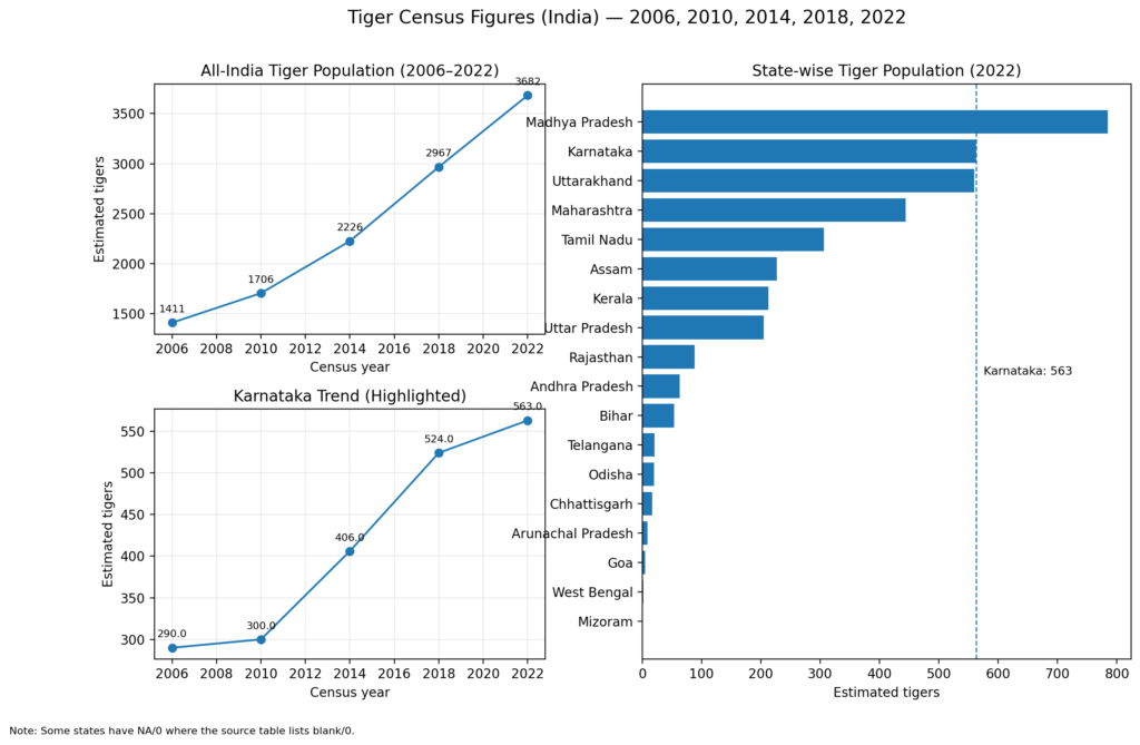
Context: tiger census got under way in Karnataka across all forest areas of the State, including the Kali, Bhadra, Nagarahole, Bandipur, and B.R.T. Tiger reserves.
It is the sixth such exercise with the enumeration conducted earlier in 2006, 2010, 2014, 2018 and 2022; in the previous census, it was estimated that Karnataka had around 563 tiger.
Karnataka has the second highest number of tigers in the country after Madhya Pradesh.
The census is part of the nationwide tiger estimation exercise which is conducted once every four years.
The 2026 census is the sixth such exercise with the enumeration conducted earlier in 2006, 2010, 2014, 2018, and 2022. In the previous census, it was estimated that Karnataka had around 563 tigers.
The census will be carried out in all patrol beats of the 38 forest divisions across every forest range in the State for which training was given to frontline personnel of the all 13 forest circles and the five tiger reserves between October and December last year.
Census in two phases
During the first phase of the enumeration for three days, teams comprising three members will patrol five km daily in forest areas across the State. They will collect details of pugmarks, scats, and direct sightings of tigers, leopards, and other carnivores and also elephants.
During the second phase, from January 15 to 17, the estimation will be conducted in 14 forest divisions, during which teams will move through forests to collect data on direct sightings of herbivores such as deer, sambar, wild buffalo, and gaur. “This will help determine where camera traps should be installed.
Project Tiger Director Ramesh Kumar who has been nominated as the nodal officer to the National Tiger Conservation Authority (NTCA) will oversee this year’s census.
“He (Ramesh Kumar) has been instructed to list the number of tigers and other carnivores in each area, assess the population of herbivores in each division, understand how many tigers each forest supports and how much prey is available for them, and thereby identify the forest’s carrying capacity,”.
Camera trap surveys
Using the data collected in the first two phases, camera traps will be installed at suitable locations in the third phase.
“There are 2,230 camera traps in the five tiger reserves and camera trap surveys have already begun in all five tiger reserves. Of these, the Nagarahole Tiger Reserve has 600 camera traps, Bandipur Tiger Reserve 550, B.R.T. Tiger Reserve 300, Bhadra Tiger Reserve 330, and Kali Tiger Reserve 450 camera traps,”.
Steps have also been taken to install camera traps outside tiger reserves.
Nearby tiger reserves that have completed camera trap surveys will provide cameras for this purpose. “It is observed that tigers are increasingly venturing out of forests into human habitations, and it appears that the tiger population in the State has increased this time. It will help to know the exact numbers through this census,”.
ಸಂದರ್ಭ: ದೇಶೀಯವಾಗಿ ವಿನ್ಯಾಸಗೊಳಿಸಿ ನಿರ್ಮಿಸಿರುವ ಮಾಲಿನ್ಯ ನಿಯಂತ್ರಣ ಹಡಗು (Pollution Control Vessel)‘ಸಮುದ್ರ ಪ್ರತಾಪ್’ ಅನ್ನು ಭಾರತೀಯ ಕರಾವಳಿ ಪಡೆಗೆ 2026ರ ಜನವರಿಯಲ್ಲಿ ಅಧಿಕೃತವಾಗಿ ಸೇವೆಗೆ ಸೇರಿತು.
4,200 ಟನ್ ತೂಕದ ಈ ಹಡಗು ಗಂಟೆಗೆ 22 ನಾಟಿಕಲ್ ಮೈಲು ವೇಗದಲ್ಲಿ ಚಲಿಸಲಿದ್ದು, 6 ಸಾವಿರ ನಾಟಿಕಲ್ ಮೈಲು ದೂರ ಚಲಿಸುವ ಸಾಮರ್ಥ್ಯ ಹೊಂದಿದೆ. 114.5 ಮೀಟರ್ ಉದ್ದವಿದ್ದು, ಶೇ 60ರಷ್ಟು ದೇಶೀಯ ವಸ್ತುಗಳಿಂದಲೇ ನಿರ್ಮಾಣಗೊಂಡಿದೆ.
ಕಡಲ ಮಾಲಿನ್ಯ ನಿಯಂತ್ರಣ ನಿಯಮಗಳು, ಕಡಲ ಕಾನೂನು ಜಾರಿ, ಶೋಧ ಮತ್ತು ರಕ್ಷಣಾ ಕಾರ್ಯಾಚರಣೆ ಗಳು ಸೇರಿದಂತೆ ವಿಶೇಷ ಆರ್ಥಿಕ ವಲಯವನ್ನು (ಇಇಝಡ್) (Exclusive Economic Zone) ರಕ್ಷಿಸುವಲ್ಲಿ ಈ ಹಡಗು ಪರಿಣಾಮಕಾರಿಯಾಗಿ ಕಾರ್ಯನಿರ್ವಹಿಸಲಿದೆ.
⚓ ಸಮುದ್ರ ಪ್ರತಾಪ್: ಪ್ರಮುಖ ಮಾಹಿತಿ
ಅಂಶ
ವಿವರ
ಹಡಗಿನ ಹೆಸರು
ಐಸಿಜಿಎಸ್ ಸಮುದ್ರ ಪ್ರತಾಪ್ (ICGS Samudra Pratap)
ಉದ್ದ ಮತ್ತು ತೂಕ
114.5 ಮೀಟರ್ ಉದ್ದ, 4,200 ಟನ್ ತೂಕ
ವೇಗ
ಗಂಟೆಗೆ 22 ನಾಟಿಕಲ್ ಮೈಲು
ಕಾರ್ಯಾಚರಣಾ ವ್ಯಾಪ್ತಿ
6,000 ನಾಟಿಕಲ್ ಮೈಲು ದೂರ ಸಂಚರಿಸಬಲ್ಲದು
ನಿರ್ಮಾಣ ಸ್ಥಳ
ಗೋವಾ ಶಿಪ್ಯಾರ್ಡ್ ಲಿಮಿಟೆಡ್ (Goa Shipyard Ltd)
ದೇಶೀಯ ಪಾಲು
ಶೇ. 60ಕ್ಕಿಂತ ಹೆಚ್ಚು ಭಾಗ ದೇಶೀಯವಾಗಿ ನಿರ್ಮಿತವಾಗಿದೆ
ಸೇರ್ಪಡೆ ದಿನಾಂಕ
5 ಜನವರಿ 2026
🌊 ಕಾರ್ಯಕ್ಷಮತೆ ಮತ್ತು ಉದ್ದೇಶ ಮಾಲಿನ್ಯ ನಿಯಂತ್ರಣ: ಸಮುದ್ರದ ಮೇಲ್ಮೈಯಲ್ಲಿ ತೈಲ ಅಥವಾ ರಾಸಾಯನಿಕ ಸೋರಿಕೆ ಸಂಭವಿಸಿದರೆ ಶುದ್ಧೀಕರಣ ಕಾರ್ಯಾಚರಣೆ ನಡೆಸಲು.
ಕಡಲ ಕಾನೂನು ಜಾರಿ: ಸಮುದ್ರದ ಕಾನೂನು ಉಲ್ಲಂಘನೆಗಳನ್ನು ತಡೆಹಿಡಿಯಲು.
ಭಾರತಕ್ಕೆ ಮಹತ್ವ ಆತ್ಮನಿರ್ಭರ ಭಾರತ: ಈ ಹಡಗು ಸಂಪೂರ್ಣವಾಗಿ ದೇಶೀಯವಾಗಿ ವಿನ್ಯಾಸಗೊಳಿಸಿ ನಿರ್ಮಿಸಲಾಗಿದೆ.
ಪರಿಸರ ಸಂರಕ್ಷಣೆಗೆ ಬಲ: ಕಡಲ ಮಾಲಿನ್ಯ ತಡೆಗೆ ತಂತ್ರಜ್ಞಾನ ಬಳಕೆ.
ರಕ್ಷಣಾ ಸಾಮರ್ಥ್ಯ: ಕರಾವಳಿ ಭದ್ರತೆಗೆ ಹೊಸ ಆಯಾಮ.
ಸಮುದ್ರ ಪ್ರತಾಪ್ ಭಾರತದ ಸಾಗರ ಸುರಕ್ಷತೆ ಮತ್ತು ಪರಿಸರ ಸಂರಕ್ಷಣೆಯಲ್ಲಿ ಹೊಸ ಅಧ್ಯಾಯವನ್ನು ಆರಂಭಿಸಿದೆ. ಇದು ತಂತ್ರಜ್ಞಾನ, ಆತ್ಮನಿರ್ಭರತೆ ಮತ್ತು ಪರಿಸರ ಜವಾಬ್ದಾರಿಯ ಸಂಕೇತವಾಗಿದೆ.
ಸಂದರ್ಭ: ‘ಭಾರತವು, ಜಗತ್ತಿನಲ್ಲಿಅತಿಹೆಚ್ಚುಅಕ್ಕಿ ಉತ್ಪಾದನೆ ಮಾಡುವ ರಾಷ್ಟ್ರವಾಗಿದೆ. ಈ ಮೂಲಕ ಅಕ್ಕಿ ಉತ್ಪಾದನೆ-ಯಲ್ಲಿ ಚೀನಾವನ್ನುಭಾರತ ಮೀರಿಸಿದೆ’ ಎಂದು ಕೇಂದ್ರ ಕೃಷಿ ಸಚಿವ.
2024-25ರ ಬೆಳೆ ವರ್ಷದಲ್ಲಿ ಭಾರತವು 15.01 ಕೋಟಿ ಟನ್ ಅಕ್ಕಿ ಉತ್ಪಾದನೆ ಮಾಡಿದೆ, ಚೀನಾ ದೇಶವು 14.52 ಕೋಟಿ ಟನ್ ಉತ್ಪಾದನೆ ಮಾಡಿದೆ. ಈ ಮೂಲಕ ಜಗತ್ತಿನಲ್ಲಿ ಅತಿ ಹೆಚ್ಚು ಅಕ್ಕಿ ಉತ್ಪಾದನೆ ಮಾಡಿದ ರಾಷ್ಟ್ರವಾಗಿ ಭಾರತ ಹೊರಹೊಮ್ಮಿದೆ.
25 ಬೆಳೆಗಳ 184 ಹೊಸ ಸುಧಾರಿತ ತಳಿಗಳನ್ನು ಬಿಡುಗಡೆ ಮಾಡಿದರು.ಈ ತಳಿಗಳನ್ನು ಭಾರತೀಯ ಕೃಷಿ ಸಂಶೋಧನಾ ಮಂಡಳಿ (ಐಸಿಎಆರ್), ಕೇಂದ್ರ ಹಾಗೂ ರಾಜ್ಯ ಕೃಷಿ ವಿಶ್ವವಿದ್ಯಾಲಯಗಳು, ಖಾಸಗಿ ಬಿತ್ತನೆ ಬೀಜ ಕಂಪನಿಗಳು ಅಭಿವೃದ್ಧಿಪಡಿಸಿವೆ.
ಈ ಹೊಸ ತಳಿಗಳು ಹೆಚ್ಚು ಇಳುವರಿ ನೀಡಲಿದ್ದು, ರೈತರ ಆದಾಯವನ್ನು ಹೆಚ್ಚಿಸಲಿವೆ. ಹೆಚ್ಚಿನ ಮಟದ ರೋಗ ನಿರೋದಕ ಶಕ್ತಿ ಹೊಂದಿವೆ.
1969 to 2014ರ ನಡುವೆ ಅಧಿಕ ಇಳುವರಿ ನೀಡುವ 3,969 ತಳಿಗಳಿಗೆ ಅನುಮೋದನೆ ನೀಡಲಾಗಿತ್ತು. ಆದರೆ, ಪ್ರಧಾನಿ ನೇತೃತ್ವದ ಸರ್ಕಾರವು ಅಧಿಕ ಇಳುವರಿ ನೀಡುವ 3,236 ತಳಿಗಳಿಗೆ ಅನುಮೋದನೆ ನೀಡಿದೆ.
✅ ಪ್ರಮುಖ ಅಂಶಗಳು: ಭಾರತ ವಿಶ್ವದ ಅತಿದೊಡ್ಡ ಅಕ್ಕಿ ಉತ್ಪಾದಕ ರಾಷ್ಟ್ರವಾಗಿದೆ (2025–26ರ ಅಂಕಿಅಂಶಗಳ ಪ್ರಕಾರ).
ಉತ್ಪಾದನೆಯ ಪ್ರಮಾಣ: ಸುಮಾರು 120–125 ಮಿಲಿಯನ್ ಟನ್ ಅಕ್ಕಿ ವರ್ಷಕ್ಕೆ.
ಮುಖ್ಯ ರಾಜ್ಯಗಳು: ಪಶ್ಚಿಮ ಬಂಗಾಳ, ಉತ್ತರ ಪ್ರದೇಶ, ಪಂಜಾಬ್, ಆಂಧ್ರ ಪ್ರದೇಶ, ತಮಿಳುನಾಡು, ಕರ್ನಾಟಕ.
ರಾಜ್ಯ
ಉತ್ಪಾದನೆ (ಲಕ್ಷ ಟನ್ಗಳಲ್ಲಿ)
ಉತ್ಪಾದನೆ (ಮಿಲಿಯನ್ ಟನ್ಗಳಲ್ಲಿ)
ಪ್ರಮುಖ ಲಕ್ಷಣ
ಉತ್ತರ ಪ್ರದೇಶ
~209.3
~20.93
ಭಾರತದ ಒಟ್ಟು ಉತ್ಪಾದನೆಯಲ್ಲಿ 14.04% ಪಾಲು.
ಪಶ್ಚಿಮ ಬಂಗಾಳ
~164.9
~16.49
ಫಲವತ್ತಾದ ಮಣ್ಣಿನಿಂದಾಗಿ ಸ್ಥಿರ ಉತ್ಪಾದನೆ.
ಪಂಜಾಬ್
~143.6
~14.36
ಅತ್ಯುತ್ತಮ ನೀರಾವರಿ ಮತ್ತು ಯಾಂತ್ರೀಕೃತ ಕೃಷಿ.
ಆಂಧ್ರ ಪ್ರದೇಶ
~78.0
~7.80
ಕೃಷ್ಣಾ-ಗೋದಾವರಿ ನದಿ ಮುಖಜ ಭೂಮಿಯಲ್ಲಿ ಹೆಚ್ಚಿನ ಬೆಳೆ.
ತಮಿಳುನಾಡು
~79.8
~7.98
ಸುಧಾರಿತ ಕೃಷಿ ಪದ್ಧತಿಗಳಿಂದ ಉತ್ಪಾದನೆ ಹೆಚ್ಚಳ.
ಕರ್ನಾಟಕ
~41.8
~4.18
ಸೋನಾ ಮಸೂರಿ ಮತ್ತು ಬಿಪಿಟಿ ತಳಿಗಳ ಹೆಚ್ಚಿನ ಉತ್ಪಾದನೆ.
ಈ ಅಂಕಿಅಂಶಗಳ ಮಹತ್ವ: ಉತ್ತರ ಪ್ರದೇಶ: ಇದು ಪ್ರಸ್ತುತ ಭಾರತದ ಅತಿ ದೊಡ್ಡ ಅಕ್ಕಿ ಉತ್ಪಾದಕ ರಾಜ್ಯವಾಗಿ ಹೊರಹೊಮ್ಮಿದೆ (ಸುಮಾರು 30.9% ರಷ್ಟು ಬೆಳವಣಿಗೆ ಕಂಡಿದೆ).
ಪಶ್ಚಿಮ ಬಂಗಾಳ: ಎರಡನೇ ಸ್ಥಾನದಲ್ಲಿದ್ದು, ದೇಶದ ಅಕ್ಕಿ ಉತ್ಪಾದನೆಯಲ್ಲಿ ಸುಮಾರು 11.06% ಪಾಲು ಹೊಂದಿದೆ.
ಕರ್ನಾಟಕ: ದಕ್ಷಿಣ ಭಾರತದ ಪ್ರಮುಖ ಅಕ್ಕಿ ಉತ್ಪಾದಕ ರಾಜ್ಯಗಳಲ್ಲಿ ಒಂದಾಗಿದ್ದು, ಗುಣಮಟ್ಟದ ಅಕ್ಕಿ ತಳಿಗಳಿಗೆ ಹೆಸರುವಾಸಿಯಾಗಿದೆ.
ಪ್ರಮುಖ ಬೆಳೆ ಕಾಲಗಳು: ಖರೀಫ್ (ಜೂನ್–ಅಕ್ಟೋಬರ್), ರಬಿ (ನವೆಂಬರ್–ಮಾರ್ಚ್).
ಭಾರತವು ಈಗ ಅಕ್ಕಿ ಉತ್ಪಾದನೆಯಲ್ಲಿ ಚೀನಾವನ್ನು ಹಿಂದಿಕ್ಕಿ ವಿಶ್ವದ ಮೊದಲ ಸ್ಥಾನಕ್ಕೇರಿದೆ.
🌍 ಜಾಗತಿಕ ಅಕ್ಕಿ ಉತ್ಪಾದನೆ: ನವೀಕರಿಸಿದ ಅಂಕಿಅಂಶಗಳು (2025-26)
ಸ್ಥಾನ
ದೇಶ
ಅಕ್ಕಿ ಉತ್ಪಾದನೆ (ಮಿಲಿಯನ್ ಟನ್ಗಳಲ್ಲಿ)
ಜಾಗತಿಕ ಪಾಲು (%)
1
ಭಾರತ
~150.18
28%
2
ಚೀನಾ
~145.28
27%
3
ಬಾಂಗ್ಲಾದೇಶ
~36.6
7%
4
ಇಂಡೋನೇಶಿಯಾ
~34.1
6%
5
ವಿಯೆಟ್ನಾಂ
~26.75
5%
ಭಾರತದ ಸಾಧನೆ: ಇತಿಹಾಸದಲ್ಲಿ ಇದೇ ಮೊದಲ ಬಾರಿಗೆ ಭಾರತವು ಚೀನಾವನ್ನು ಹಿಂದಿಕ್ಕಿ ವಿಶ್ವದ ಅತಿದೊಡ್ಡ ಅಕ್ಕಿ ಉತ್ಪಾದಕ ದೇಶವಾಗಿ ಹೊರಹೊಮ್ಮಿದೆ.
ಹೊಸ ತಳಿಗಳ ಪಾತ್ರ: ಭಾರತೀಯ ಕೃಷಿ ಸಂಶೋಧನಾ ಮಂಡಳಿ (ICAR) ಅಭಿವೃದ್ಧಿಪಡಿಸಿದ 184ಕ್ಕೂ ಹೆಚ್ಚು ಹೊಸ ಮತ್ತು ಹವಾಮಾನ-ನಿರೋಧಕ ಬಿತ್ತನೆ ಬೀಜದ ತಳಿಗಳು ಈ ದಾಖಲೆಯ ಉತ್ಪಾದನೆಗೆ ಮುಖ್ಯ ಕಾರಣವಾಗಿವೆ.
ರಫ್ತು: ಭಾರತವು ಕೇವಲ ಉತ್ಪಾದನೆಯಲ್ಲಿ ಮಾತ್ರವಲ್ಲದೆ, ಜಾಗತಿಕ ಅಕ್ಕಿ ರಫ್ತಿನಲ್ಲೂ ಶೇ. 40 ಕ್ಕಿಂತ ಹೆಚ್ಚು ಪಾಲನ್ನು ಹೊಂದುವ ಮೂಲಕ ಅಗ್ರಸ್ಥಾನದಲ್ಲಿದೆ.
📦 ರಫ್ತು ಮತ್ತು ಆರ್ಥಿಕತೆ ಭಾರತ ಅಕ್ಕಿ ರಫ್ತಿನಲ್ಲಿ ಕೂಡ ಅಗ್ರಸ್ಥಾನದಲ್ಲಿದೆ.
ಪ್ರಮುಖ ರಫ್ತು ಗುರಿಗಳು: ನೇಪಾಳ, ಬಾಂಗ್ಲಾದೇಶ, UAE, ಸೌದಿ ಅರೇಬಿಯಾ, ಆಫ್ರಿಕಾದ ರಾಷ್ಟ್ರಗಳು.
ಬಾಸ್ಮತಿ ಅಕ್ಕಿ: ಅತ್ಯಧಿಕ ಮೌಲ್ಯದ ರಫ್ತು ಉತ್ಪನ್ನ.
🌱 ಸವಾಲುಗಳು ನೀರಿನ ಅವಲಂಬನೆ: ಅಕ್ಕಿ ಬೆಳೆಗೆ ಹೆಚ್ಚಿನ ನೀರಿನ ಅಗತ್ಯವಿದೆ.
ಹವಾಮಾನ ಬದಲಾವಣೆ: ಮಳೆಯ ಅವಿಶ್ವಾಸಾರ್ಹತೆ ಉತ್ಪಾದನೆಗೆ ಧಕ್ಕೆ.
ಮಣ್ಣಿನ ಗುಣಮಟ್ಟ ಮತ್ತು ರಾಸಾಯನಿಕ ಬಳಕೆ.
ಭಾರತ ಅಕ್ಕಿ ಉತ್ಪಾದನೆಯಲ್ಲಿ ಅಗ್ರಗಣ್ಯ ಸ್ಥಾನದಲ್ಲಿದ್ದು, ಆಹಾರ ಭದ್ರತೆ ಮತ್ತು ಆರ್ಥಿಕತೆಗೆ ಮಹತ್ವದ ಕೊಡುಗೆ ನೀಡುತ್ತಿದೆ. ಮುಂದಿನ ವರ್ಷಗಳಲ್ಲಿ ಸ್ಥಿರ ನೀತಿ, ತಂತ್ರಜ್ಞಾನ, ಮತ್ತು ಪರಿಸರ ಸ್ನೇಹಿ ಕೃಷಿ ವಿಧಾನಗಳು ಈ ಕ್ಷೇತ್ರವನ್ನು ಇನ್ನಷ್ಟು ಬಲಪಡಿಸಬಹುದು.
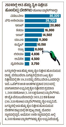
ಜಗತ್ತಿನಲ್ಲೇ ಅತಿ ಹೆಚ್ಚು ತೈಲ ನಿಕ್ಷೇಪಗಳನ್ನು ಹೊಂದಿರುವ ರಾಷ್ಟ್ರವಾಗಿರುವ ವೆನೆಜುವೆಲಾ, ಸುಮಾರು ಮೂರು ಶತಮಾನ ಸ್ಪೇನ್ನ ವಸಾಹತುವಾಗಿತ್ತು.ಸ್ಪೇನ್ನಿಂದ ಸ್ವಾತಂತ್ರ್ಯ ಪಡೆದನಂತರನೆರೆಯ ರಾಷ್ಟ್ರಗಳೊಂದಿಗೆ ಗಡಿ ವಿವಾದ, ಸರ್ವಾಧಿಕಾರ, ಸೇನಾ ದಂಗೆಯಿಂದ ತೆವಳುತ್ತಾ ಸಾಗುತ್ತಿದ್ದವೆನೆಜುವೆಲಾಗೆ ಸ್ಥಿರತೆ ತಂದುಕೊಟ್ಟು, ಅದನ್ನು ಅಭಿವೃದ್ಧಿಯ ಪಥದಲ್ಲಿ ನಡೆಯುವಂತೆ ಮಾಡಿದ್ದು ಹೂಗೊ ಚಾವೇಸ್.ಎಡಪಂಥೀಯರಾಗಿದ್ದಚಾವೇಸ್, ಉದ್ದಿಮೆಗಳ ರಾಷ್ಟ್ರೀಕರಣ ಸೇರಿದಂತೆ ಹಲವು ಕ್ರಮಗಳನ್ನು ಕೈಗೊಂಡು ಆರ್ಥಿಕ ಬೆಳವಣಿಗೆ ಸಾಧಿಸಿದರು. ಆದರೆ, ಸರ್ವಾಧಿಕಾರಿ ಎನ್ನುವ ನೆಪದಲ್ಲಿ ದೇಶದ ಒಳಗೆ ಮತ್ತು ಹೊರಗೆ ಅವರ ವಿರೋಧಿಗಳು ಹೆಚ್ಚಾದರು. ದೇಶದ ಹೊರಗಿನ ವಿರೋಧಿಗಳಲ್ಲಿ ಅಮೆರಿಕ ಪ್ರಮುಖವಾದರೆ, ಒಳಗಿನ ವಿರೋಧಿಗಳಲ್ಲಿ ಮಾರಿಯಾ ಕೊರಿನಾ ಮಚಾದೊ ಪ್ರಮುಖರಾಗಿದ್ದರು. ಅಮೆರಿಕದ ವಿರೋಧಕ್ಕೆ ಕಾರಣವಾಗಿದ್ದು ಇಂಧನ ವ್ಯಾಪಾರ.
ಅಮೆರಿಕ ಕಣ್ಣು ತೈಲದ ಮೇಲೆ: ವೆನೆಜುವೆಲಾದ ಅನಿಲ ಸಂಪನ್ಮೂಲಗಳ ಮೇಲೆ ಅಮೆರಿಕ ದೀರ್ಘಕಾಲದಿಂದಲೂ ಕಣ್ಣಿಟ್ಟಿದೆ. 1920ರಿಂದಲೂ ಅಮೆರಿಕದ ಕಂಪನಿಗಳು ವೆನೆಜುವೆಲಾದಲ್ಲಿ ತೈಲವ್ಯಾಪಾರ ಮಾಡುತ್ತಿದ್ದವು. 1976ರಲ್ಲಿ ವೆನೆಜುವೆಲಾದಲ್ಲಿ ಸರ್ಕಾರಿ ಸ್ವಾಮ್ಯದ ಇಂಧನ ಮತ್ತು ನೈಸರ್ಗಿಕ ಅನಿಲ ಕಂಪನಿಯನ್ನು ಸ್ಥಾಪಿಸಿದರೂ ಅಮೆರಿಕವು ಪಾಲುದಾರಿಕ ಮತ್ತು ಇತರ ಪರೋಕ್ಷ ವಿಧಾನಗಳಲ್ಲಿ ತೈಲ ವ್ಯಾಪಾರ ಮುಂದುವರಿಸಿತ್ತು.ಆದರೆ, ಚಾವೇಸ್ ಅಧ್ಯಕ್ಷರಾದ (1998) ನಂತರ ರಾಷ್ಟ್ರೀಕರಣದಿಂದ ನಿಯಮಗಳು ಬಿಗಿಯಾಗಿ, ಅಮೆರಿಕ ವೆನೆಜುವೆಲಾದ ತೈಲ ಮಾರುಕಟ್ಟೆಯಿಂದ ಹೊರಬರಲೇಬೇಕಾಯಿತು. ಕಮ್ಯುನಿಸ್ಟ್ ವೆನೆಜುವೆಲಾ ಕಮ್ಯುನಿಸ್ಟ್ ಚೀನಾದತ್ತ ವಾಲಿತು. ಚೀನಾಕ್ಕೆ ತೈಲರಫ್ತು ಮಾಡತೊಡಗಿತು.ಅಮೆರಿಕವು ವೆನೆಜುವೆಲಾ ಮೇಲೆ ಹಲವು ರೀತಿಯ ನಿರ್ಬಂಧ ಹೇರಿದ್ದಲ್ಲದೇ ಆಗಿನಿಂದಲೂ ವೆನೆಜುವೆಲಾ ಮೇಲೆ ಹಿಡಿತ ಸಾಧಿಸಲು ಪ್ರಯತ್ನಿಸುತ್ತಲೇ ಇತ್ತು.
ಚಾವೇಸ್ ನಂತರ ಅವರ ಉತ್ತರಾಧಿಕಾರಿಯಾಗಿ ಬಂದ ನಿಕೊಲಸ್ ಮಡೂರೊ ಕೂಡ ಚಾವೇಸ್ ಅವರ ಅಮೆರಿಕ ವಿರೋಧಿ ನಿಲುವನ್ನು ಮುಂದುವರಿಸಿದರು. ಆದರೆ, ತೈಲದ ಬೆಲೆ ಏರಿಳಿತ, ವಿರೋಧಿಗಳ ಪಿತೂರಿ ಮುಂತಾದ ಕಾರಣಗಳಿಂದ ವೆನೆಜುವೆಲಾದ ಆರ್ಥಿಕ ಸ್ಥಿತಿ ಹದಗೆಡುತ್ತಾ ಬಂದಿತು. ಆಹಾರ ಧಾನ್ಯಗಳ ಬೆಲೆ ಏರಿಕೆ. ಬಡತನ ಹೆಚ್ಚಾಯಿತು. ಲಕ್ಷಾಂತರ ಮಂದಿ ದೇಶ ತೊರೆದರು. ಇಪ್ಪಾದರೂ ಸತತ ಮೂರು ಚುನಾವಣೆಗಳಲ್ಲಿ (2013, 2018. 2024) ಜಯಗಳಿಸಿ ಅಧ್ಯಕ್ಷರಾಗಿ ಮುಂದುವರಿದರು.ಅವರು ಚುನಾವಣೆಗಳನ್ನು ಆಕ್ರಮವಾಗಿ ಗೆಲ್ಲುತ್ತಿದ್ದಾರೆ ಎನ್ನುವುದು ವಿರೋಧಿಗಳವಾದವಾಗಿತ್ತು.
ಚೀನಾ ಪ್ರಭಾವ ತಗ್ಗಿಸುವ ಉದ್ದೇಶ ಭೌಗೋಳಿಕವಾಗಿ ಪಶ್ಚಿಮದ ರಾಷ್ಟ್ರಗಳಲ್ಲಿ ತನ್ನ ಪ್ರಾಬಲ್ಯವನ್ನು ಮತ್ತಷ್ಟು ಹೆಚ್ಚಿಸುವುದು ಅಮೆರಿಕದ ಈಕ್ರಮದ ಹಿಂದಿನ ಮತ್ತೊಂದು ಕಾರಣವಾದರೆ, ದಕ್ಷಿಣ ಅಮೆರಿಕದ ವ್ಯಾಪ್ತಿಯಲ್ಲಿ ಚೀನಾ ಮತ್ತು ರಷ್ಯಾ ಪ್ರಭಾವವನ್ನು ತಗ್ಗಿಸುವುದು ಮಗದೊಂದು ಕಾರಣ.
ವೆನೆಜುವೆಲಾ ಸೇರಿದಂತೆ ದಕ್ಷಿಣ ಅಮೆರಿಕದ ಹಲವು ರಾಷ್ಟ್ರಗಳಲ್ಲಿ ಚೀನಾವು ಬೆಲ್ಸ್ ಆ್ಯಂಡ್ ರೋಡ್ ಇನಿಷಿಯೇಟಿವ್ ಮೂಲಕ ಭಾರಿ ಪ್ರಮಾಣದಲ್ಲಿ ಬಂಡವಾಳ ಹೂಡಿದೆ. ತನ್ನ ಮಹತ್ವಾಕಾಂಕ್ಷೆ ಯೋಜನೆಗೆ ಈ ಭಾಗದ 24 ರಾಷ್ಟ್ರಗಳು ಸಹಿ ಹಾಕಿವೆ ಎಂದು ಚೀನಾ ಈ ಹಿಂದೆ ಹೇಳಿಕೊಂಡಿತ್ತು. ಇಲ್ಲಿನ ಹಲವು ದೇಶಗಳಿಗೆ ಚೀನಾ ದೊಡ್ಡ ವ್ಯಾಪಾರ ಪಾಲುದಾರ ರಾಷ್ಟ್ರಗಳಲ್ಲೊಂದು. ಚೀನಾದೊಂದಿಗೆ ಪಾಲುದಾರಿಕೆ ಇದ್ದಹೊರತಾಗಿಯೂ ಈ ವಲಯದ ಹಲವು ರಾಷ್ಟ್ರಗಳು ಅಮೆರಿಕದೊಂದಿಗೆ ಉತ್ತಮ ಬಾಂಧವ್ಯ ಹೊಂದಿವೆ. ಆದರೆ, ವೆನೆಜುವೆಲಾ ಮತ್ತು ಕ್ಯೂಬಾ ಅಮೆರಿಕದ ವಿರುದ್ಧ ತೊಡೆ ತಟ್ಟಿದ್ದವು.
ಇತ್ತೀಚಿನ ವರ್ಷಗಳಲ್ಲಿ ಅಮೆರಿಕವು ಕ್ಯೂಬಾಕ್ಕಿಂತಲೂ ವೆನೆಜುವೆಲಾವನ್ನೇ ಹೆಚ್ಚು ಗುರಿಯಾಗಿಸಿಕೊಂಡಿತ್ತು.
ಅಮೆರಿಕದಿಂದ ದೂರವಾದ ಬಳಿಕ ಚೀನಾವು ವೆನೆಜುವೆಲಾಕ್ಕೆ ಹತ್ತಿರವಾಗಿತ್ತು.
ಚೀನಾವು ಅಲ್ಲಿನ ಇಂಧನ ಕ್ಷೇತ್ರದಲ್ಲಿ ಭಾರಿ ಪ್ರಮಾಣದಲ್ಲಿ ಹೂಡಿಕೆ ಮಾಡಿದೆ. ವೆನೆಜುವೆಲಾವು ತಾನು ಉತ್ಪಾದಿಸುವ ಒಟ್ಟು ತೈಲದಲ್ಲಿ ಶೇ 80ರಷ್ಟನ್ನು ಚೀನಾಕ್ಕೆ ಮಾರುತ್ತಿದೆ. 2024ರಲ್ಲಿ ಅಮೆರಿಕವು ವೆನೆಜುವೆಲಾದ ಮೇಲೆ ನಿರ್ಬಂಧಗಳನ್ನು ಹೇರಿದ ನಂತರ ಚೀನಾವು ಹೂಡಿಕೆಯನ್ನು ಸ್ವಲ್ಪ ಕಡಿಮೆ ಮಾಡಿದ್ದರೂ ಇಂಧನ ಕ್ಷೇತ್ರದಲ್ಲಿ ಪರಸ್ಪರ ಸಹಕಾರ ಮುಂದುವರಿದಿತ್ತು.
ಚೀನಾ ಕಾನ್ಕೋರ್ಡ್ ರಿಸೋರ್ಸಸ್ ಕಾರ್ಪೊರೇಷನ್ ಎಂಬ ಖಾಸಗಿ ಕಂಪೆನಿಯುವೆನೆಜುವೆಲಾದ ಸರ್ಕಾರಿ ಸ್ವಾಮ್ಯದತೈಲ ಕಂಪನಿಯೊಂದಿಗೆ ಮ್ಯಾರಕ್ಕೆಬೊ ಸರೋವರದಲ್ಲಿ ಎರಡು ತೈಲ ಉತ್ಪಾದನಾ ಘಟಕ ಅಭಿವೃದ್ಧಿಪಡಿಸಲು 100 ಕೋಟಿ ಡಾಲರ್ ಮೊತ್ತದ ಒಪ್ಪಂದ ಮಾಡಿಕೊಂಡಿತ್ತು.
ವೆನೆಜುವೆಲಾ ಸಂಕಷ್ಟ: ಭಾರತದ ಇಂಧನ ಭದ್ರತೆಗೆ ಪರಿಣಾಮವಿಲ್ಲ 2025ರ ನವೆಂಬರ್ವರೆಗೆ ನಡೆದ ಪ್ರಸ್ತುತ ಹಣಕಾಸು ವರ್ಷದಲ್ಲಿ ಭಾರತದ ಒಟ್ಟು ತೈಲ ಆಮದುಗಳಲ್ಲಿ ವೆನೆಜುವೆಲಾ ಕ್ರೂಡ್ ಕೇವಲ 0.3% ಮಾತ್ರ. 2019ರಿಂದಲೇ ಅಮೆರಿಕದ ನಿರ್ಬಂಧಗಳ ಹಿನ್ನೆಲೆಯಲ್ಲಿ ಭಾರತವು ವೆನೆಜುವೆಲಾದಿಂದ ತೈಲ ಆಮದು ಕಡಿಮೆ ಮಾಡುತ್ತಿದೆ.
ಅಮೆರಿಕದ ದಾಳಿ ಮತ್ತು ಭಾರತದ ಸ್ಥಿತಿ ಅಮೆರಿಕವು ವೆನೆಜುವೆಲಾದ ಮೇಲೆ ನಡೆಸಿದ ದಾಳಿ ಭಾರತದ ಇಂಧನ ಭದ್ರತೆಗೆ ನೇರ ಪರಿಣಾಮ ಬೀರುವ ಸಾಧ್ಯತೆ ಇಲ್ಲವೆಂದು ಇತ್ತೀಚಿನ ಅಂಕಿಅಂಶಗಳು ತೋರಿಸುತ್ತವೆ.
ವಾಣಿಜ್ಯ ಮತ್ತು ಕೈಗಾರಿಕಾ ಸಚಿವಾಲಯದ ಮಾಹಿತಿ: 2025ರ ನವೆಂಬರ್ವರೆಗೆ ಭಾರತವು ವೆನೆಜುವೆಲಾದಿಂದ 255.3 ಮಿಲಿಯನ್ ಡಾಲರ್ ಮೌಲ್ಯದ ತೈಲವನ್ನು ಆಮದು ಮಾಡಿದೆ. ಇದು ಒಟ್ಟು ಆಮದುಗಳಲ್ಲಿ ಕೇವಲ 0.3%.
2013ರ ಸ್ಥಿತಿ: ಆ ಸಮಯದಲ್ಲಿ ಭಾರತವು ವೆನೆಜುವೆಲಾದಿಂದ 13 ಬಿಲಿಯನ್ ಡಾಲರ್ ಮೌಲ್ಯದ ತೈಲವನ್ನು ಆಮದು ಮಾಡಿತ್ತು.
2019ರಿಂದ: ಅಮೆರಿಕದ ನಿರ್ಬಂಧಗಳು ಮತ್ತು ದ್ವಿತೀಯ ನಿರ್ಬಂಧಗಳ ಭೀತಿಯಿಂದ ಭಾರತವು ವೆನೆಜುವೆಲಾದೊಂದಿಗೆ ವ್ಯಾಪಾರವನ್ನು ಕಡಿಮೆ ಮಾಡಿತು.
“ಕಡಿಮೆ ವ್ಯಾಪಾರ ಪ್ರಮಾಣ, ಈಗಾಗಲೇ ಜಾರಿಯಲ್ಲಿರುವ ನಿರ್ಬಂಧಗಳು ಮತ್ತು ಭೌಗೋಳಿಕ ಅಂತರ—ಒಟ್ಟಾಗಿ ದೃಢಪಡಿಸುತ್ತದೆ ವೆನೆಜುವೆಲಾದ ಇತ್ತೀಚಿನ ಬೆಳವಣಿಗೆಗಳು ಭಾರತದ ಆರ್ಥಿಕತೆ ಅಥವಾ ಇಂಧನ ಭದ್ರತೆಗೆ ಯಾವುದೇ ಮಹತ್ವದ ಪರಿಣಾಮ ಬೀರುವುದಿಲ್ಲ,” ಎಂದು ವಿಶ್ಲೇಷಕರು ಹೇಳಿದ್ದಾರೆ.
OPEC ಸದಸ್ಯತ್ವ ವೆನೆಜುವೆಲಾ OPEC (Organization of the Petroleum Exporting Countries) ಸದಸ್ಯ ರಾಷ್ಟ್ರ. ಈ ಗುಂಪು ಜಾಗತಿಕ ತೈಲ ಮಾರುಕಟ್ಟೆಯನ್ನು ಬಹುಮಟ್ಟಿಗೆ ನಿಯಂತ್ರಿಸುತ್ತದೆ.
ವೆನೆಜುವೆಲಾ ಪ್ರಸ್ತುತ ಇತರ ರಾಷ್ಟ್ರಗಳಿಗಿಂತ ಕಡಿಮೆ ಪ್ರಮಾಣದ ಕ್ರೂಡ್ ತೈಲವನ್ನು ಉತ್ಪಾದಿಸುತ್ತದೆ.
OPEC ಅಂಕಿಅಂಶಗಳ ಪ್ರಕಾರ, ವೆನೆಜುವೆಲಾ OPEC ಒಟ್ಟು ತೈಲ ರಫ್ತುಗಳಲ್ಲಿ 3.5% ಮತ್ತು ಜಾಗತಿಕ ತೈಲ ಸರಬರಾಜಿನಲ್ಲಿ 1% ಮಾತ್ರ.
ಭಾರವಾದ ತೈಲ (Heavy Oil) ವೆನೆಜುವೆಲಾದ ತೈಲವು ಭಾರವಾದ ಸ್ವರೂಪ ಹೊಂದಿರುವುದರಿಂದ ಅದನ್ನು ಸಂಸ್ಕರಿಸಲು ವಿಶೇಷ ಶುದ್ಧೀಕರಣಾಲಯಗಳು ಅಗತ್ಯ. ಆದರೆ ಇಂತಹ ಶುದ್ಧೀಕರಣಾಲಯಗಳು ಬಹುತೇಕ ರಾಷ್ಟ್ರಗಳಲ್ಲಿ ಲಭ್ಯವಿಲ್ಲ.
ಅಮೆರಿಕದ ನಿರ್ಬಂಧಗಳ ಪರಿಣಾಮವಾಗಿ ವೆನೆಜುವೆಲಾದ ತೈಲದ ಜಾಗತಿಕ ಸರಬರಾಜು ಕುಸಿದಿದೆ.
ಪ್ರಸ್ತುತ ಉತ್ಪಾದನೆಯ ಹೆಚ್ಚಿನ ಭಾಗವನ್ನು ಚೀನಾಕ್ಕೆ ರಫ್ತು ಮಾಡಲಾಗುತ್ತಿದೆ.